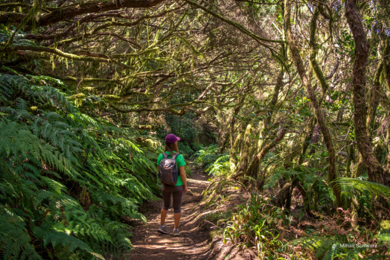
Let’s get down to business. We park the car on the shoulder here. As usual, we rented the car from Pluscar. I don’t know if it’s possible to get here by bus. We are immediately greeted by an unusual path. You won’t get lost there.

First, my epic drone video:
We reach a huge tree. We hug it, take photos. We’ve been on this track 3 times already, so I’m attaching photos from different years. Once we even walked in the fog, right in the clouds.

I’m attaching the route plan, starting from the parking here. The length is about 14 km. The elevation changes are small, the only difficulty is climbing up Montaña Negra, its height is 80 m, but you can skip it.

We follow the circular Chinyero PR-TF 43 trail clockwise, following the signs. This part runs through the forest with Canary pines around the crater. The crater itself is not very obvious, it’s all overgrown.

This is where the most interesting part begins. We climb up the stairs and find ourselves in another world.

Imagine the Teide volcano erupting, with orange-red lava flowing, forming rivers and banks, burning and destroying all life in its path.

Lifeless areas among the forest have remained. The last eruption of the volcano was quite recent – in 1909. Our route runs through this harsh beauty.

Remember! There are many cavities in the folds, so don’t stray from the path. There could be caves under the thin crust. Look, they are quite large. On the island, there are even routes through underground lava rivers.

In the middle of the river, there is a rock.

From the drone, you can see how the molten magma flowed.

Among the lifeless rocks, life is teeming. The black stones are covered with colorful lichens. Spanish moss hangs from the pines like Santa Claus’s beard.

In the distance, the handsome Teide peeks out from behind the clouds. It can be seen from many parts of the island.
Want to know how tall it is? 3,718 meters. And if you count the underwater part, the height from the bottom to the top is 7,500m. It’s the highest peak in the Atlantic Ocean. Tenerife is the 3rd largest volcanic island in the world by volume.

As we were talking, we reached Montaña Negra. Now we’ll climb it.

Around are evenly planted pines. Notice the contrasting black soil and circles of dry needles under each pine.

Once, we got caught in heavy fog. We were walking right in the cloud. Nothing was visible. And do you know why clouds sometimes cover the area? Because the altitude is around 1,300m. Sometimes you walk above the clouds, and sometimes they cover you. At that moment, you feel the cold. A damp, piercing cold.

Around the mountain, among the black rocks, there are light white chitinous insect remains. I don’t know what they are. They look like millipede pupae. They’re empty inside. Something has been reborn and run away.

We huffed and puffed a bit and climbed the mountain. You can see the entire western coast of the island from north to south. We sat and looked around for an hour.

As I launched the drone, clouds suddenly rushed in. They enveloped the mountain around us. We found ourselves in a fairy tale, walking in the clouds. A piercing cold wind came with them. The clouds and wind disappeared as suddenly as they appeared.

If you fly up to 150m, our mountain no longer seems big compared to the giant Teide.

We descend. The last time, my mom joined us. So there was someone to take pictures of us.

Now we go around the mountain from the other side. It’s important to find this trail. There are almost no signs for it. It’s better if you use the maps.me app on your phone. But once you find it, you won’t get lost.

The road winds between ravines and leads to a picnic area. Look for the Arenas Negras signs. Just in case, I’ll give you the coordinates of the area.
It’s time to eat what you’ve been carrying all the way. We take out boiled eggs, sandwiches with sausage and cheese. Bring some ham, delicious Canarian bananas and tomatoes. Let’s have a feast. There’s a good clean toilet in the picnic area, many drinking fountains and dining tables. There are several grill areas, even firewood is provided.
 While we were eating, a sad, hungry little dog came to us. Stray animals are a rarity in the Canary Islands and even in Spain. Most likely, she got lost. It was clear that she had been living in the forest for a long time. She businesslike asked for water from the fountain to be poured for her. Lena poured some water into a bag and left it for the dog. Mom took pity and gave her pancake, and then another one. The dog didn’t eat my pear, but ate the egg. She thanked us and ran back into the forest, limping slightly due to the sharp stones.

Lena found a huge spit. I can imagine a huge Canarian family bringing a whole piglet and roasting it over a huge bonfire.

Then an unexpected thing happened. We got so carried away that we didn’t calculate the time for the way back, and it takes 2 hours to walk back. The sun insidiously set first behind the clouds, then quietly retreated behind the mountains. We had 40 minutes left to walk. At that moment, it winked at us with a red sunset, and darkness fell.

We found ourselves alone with shadows from branches, black silhouettes of mountains, and an invisible path. Stones started appearing more and more often out of the darkness and attacking my feet, while branches grabbed my pants. At that moment, you’re glad that Tenerife has a very scarce animal life.
But then the great and mighty flashlight on the phone comes to the rescue! It lit up the path ahead, chased away the stones and branches, and led us to the parking lot.
In my experience, it’s best to start a hike between 9 and 11 a.m. We were late and set out at 12:30, so we didn’t make it in time. Calculate your time! Sunset in November is around 6:30 p.m.
I hope I’ve piqued your interest, and you’ll take this hike on your next trip. Share your favorite hiking routes on Tenerife in the comments.
- Маршрут по вулканам около Тейде
- GPS: 28,2848476 -16,7650521